In the predawn hours of this past Sunday, a boundary lifting NE as a warm front sparked off a line of strong storms to the NW. Though activity was forecast to be no further S than along I-74 which runs N of my location, a rouge cell would develop at Lincoln and drop into my lap. Stuck at work unfortunately and unable to be in a more suitable location out in the country, I put a camera out to see what it would capture. Despite no awesome nocturnal structure for being washed out by city light, the event was a fitting entrance to a month when thunderstorm activity increases dramatically.
I'm the dot (c/o Spotter Network)
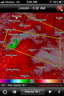
Once this cell passed, that was it for my location but my attention would be drawn to other regional storms further upstream. In the grab below (c/o Radarscope), a return indicative of strong downburst winds at Pekin captured my interest. The green would go white for the next scan thus signifying very intense winds. The warning at this time was for winds up to 70 MPH and it wouldn't have surprised me to have verified.
Both cells were reportedly producing hail up to the size of golfballs. Friends in that area were seeing and photographing intense lightning.


No comments:
Post a Comment