Facing N, note the green on the horizon. Though the best and brightest has come and gone, there was still a very faint ribbon of green and red arcing across the sky. These pictures were lightened to reveal the color thus why they look like garbage but I'm not trying to win any prizes with this mess.

Facing NW, a brief break in the cloud at upper left reveals some of the red before filling back in.

I was shooting continuous as usual hoping that a stack would reveal some detail which it did somewhat (namely greens) but the cloud just wasn't having it as evident by the limited trails. I also took the stills and created an animation video found HERE.


The last major event of note where auroras made it this far S was in 2004. I did not witness this event and the last time I personally observed them was during the winter of 2001 which was total luck as I just happened to be out and driving to work. To say I am a little miffed that the clouds ruined this major once in a lifetime opportunity is an understatement. More than any subject I have ever covered, I want to capture the aurora borealis and not simply half assed like this set. Others around the nation were much more fortunate than I and thus, I have included links to several other accounts. I'm probably missing a few but the last link to spaceweather was naturally all over it.
BRIAN EMFINGER, ARKANSAS
STEPHEN LOCKE, KANSAS (video)
BILL DOMS, MINNESOTA
SCOTT WEBERPAL, WISCONSIN
ANDREW PRITCHARD, ILLINOIS
DAN ROBINSON, ILLINOIS
BEAU DODSON, ILLINOIS
SPACEWEATHER.COM
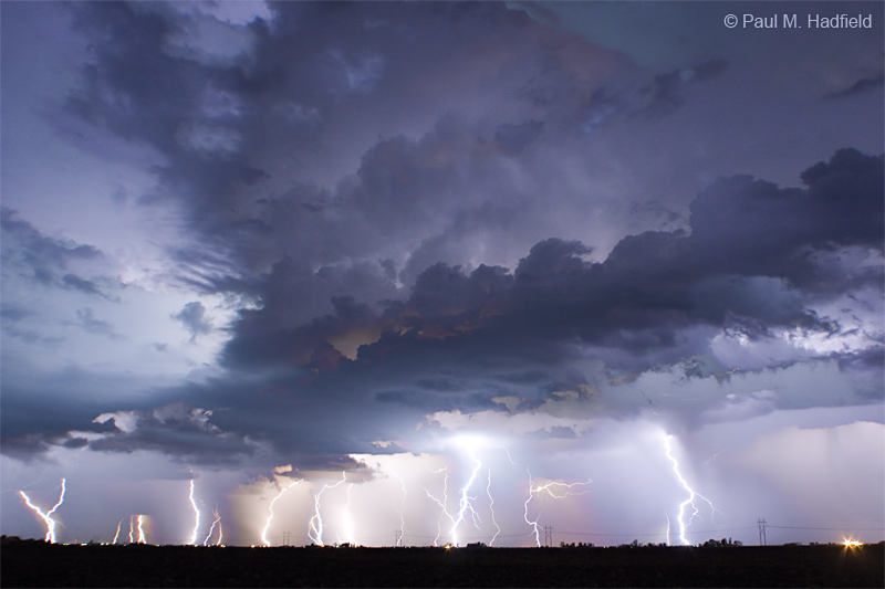
Per the second part of this entry, a cold front was scheduled to pass on the Tuesday overnight. It was not expected to amount to much with only a marginal chance of severe much further W near the Mississippi river. I would go to bed early only to automatically awake around 10:30 PM. Looking at radar, a strong cell was coming in from the W with time for me to get up, grab my gear and take off so I did. Setting up a short distance from home in a position that would keep me mostly rain free, the incoming storm was a vigorous one. I shot continuous for the purpose of assembling a time lapse found HERE and was treated to several good keepers below.


Pointing towards the WSW for a few frames thinking there was new development on the SW flank, this was about as good as it got. The storm collapsed nearly overhead leaving nothing to follow so I went home. How's that for timing?

Just for fun I took the stills used for the animation video and ran them through the star trails program to generate a creative stack comprised of 25 minutes as a single image.
2 comments:
Awesome lightning shots Paul. I like the image you put together of all those lightning strikes in one photo also.
Cool northern lighs pictures too. A rare event in this area.
Post a Comment