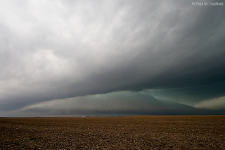
A stalled frontal boundary draped across the state last week brought periodic showers and storms. Wednesday was the day of greatest interest as the parent system out west lifted across the area and put us in a slight risk for severe weather. A morning outflow boundary would drop through and make conditions less favorable for storm development or so we thought as a tornado warned cell would form across EC IL with a secondary round of storms after the outflow passage. The day would end up being cloudy, cool, showery and overall stable. I was out with the secondary round and chose to stay up this way instead of drop SE with the boundary and thus, missed the tornado warned storm. Afternoon development just to the S of the warm front which had nudged its way down to I-72 would however, produce a remarkable storm with jaw dropping structure from inside Christian County. Heavy rains through the overnight with the cold front passage effectively put any drought concern to rest.
Morning outflow from earlier storms up N.

Approaching hail core from the secondary round that produced 1/2" to 3/8" stones at my location.

Much later from just S of I-72 and watching turbulence along the boundary.

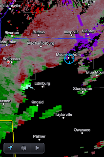
Attention quickly turned to activity approaching from the SW that was generating a significant velocity return.

(c/o
RadarScope)
Yes please...

180° panoramas featuring the unbelievable dual tail cloud formations.


Continuing from behind, upstream development including rapid scud ascension along with noticeable (albeit disorganized) rotation. The storm would go severe but I would let it go for lacking fuel and needing to get back home.

Extremely heavy drought busting rains through the overnight.

(c/o
RadarScope)
From Saturday evening, at the same time last year, this portion of Lake Decatur was dry.


1 comment:
smokers that's some cloud
looks ike the mother ship about to land
Post a Comment