Saturday, January 18, 2014

Sunrise Tech

Yet another clipper in what has been a seemingly endless string of systems dropping in from the northwest made its appearance across the region Saturday. Knowing that snow was forecast for late morning into midday, I had a hunch that lead edge cloud in advance of the parent low would be in place for a daybreak photo opportunity. Initially at civil twilight when I could visually identify the situation, I thought it might bust given the lackluster fade of light typical if the cloud shield is too far ahead. Once the suns rays crept over the horizon at just the right angle however, the base lit up like someone flipped a switch. Rather than be another generic post showcasing the moment without much commentary, I have decided to include some personal notes so that you might get more from your own sunrise/sunset experiences.

"Red sky at morning, Sailors take warning" is not an old wives tale but a true assessment for a pending weather situation. Located in Central Illinois, the cloud I am interested in is already streaming into Indiana. The base illuminates as it does because from the far eastern deck edge trailing back to the west, cloud altitude lowers with the phasing of a departing high pressure to the east into an approaching low pressure to the west. As a result, the sun beams across an ever so slightly angled plane creating the change of color value from bright yellow at horizon to magenta the further you get from the source. Rayleigh scattering is the process in which water molecules and airborne particles separate white light into the range of the visible spectrum to where only the longer wavelengths of red are available. When up all night, I keep tabs on infrared satellite activity as you can often predict if there will be anything worth paying attention to while it is still dark.

c/o COD Meteorology

For all of the images, I shot ISO 200, F8.0, A/v Mode and let the shutter be determined on its own. White balance is auto as I simply correct if necessary during editing.

Through a Tamron 10-22 wide angle lens cropped to Facebook cover photo aspect ratio of 851:315. I like this style of cropping as it renders a somewhat generic panorama.


Cropped to 16:9 aspect ratio, when it starts to pop I will stop down -0.3 to help keep the brightest areas in check.


Virtually the same as the first example but notice the dramatic changes. Continuity with so many things happening between the lights and darks is difficult to maintain thus why I allow the in-camera metering to do the work for me. Seems lazy but the window from initial illumination to sun appearance is roughly 15 minutes.


16:9 aspect ratio with attempted emphasis on leading lines.


16:9 aspect ratio through a Tamron 28-80 with off center attempted emphasis on balancing dark subject at left with highlight at right.


16:9 aspect ratio with attempted emphasis like previous but opposite.


3:2 aspect through Canon 75-300 with attempted emphasis on left horizon dip as weight balance. It can be a challenge to find decent, non-intrusive subjects in the heart of agribusiness land where there is little more than power poles or cell towers. If nothing is available, I look for 'anti-subjects' such as this.


3:2 aspect through Canon 75-300, off center and vertical to demonstrate that if an event doesn't pop across the entire sky, you can often get a dramatic scene by zooming into the horizon. I usually like to align a tree or other subject at the point of light as this also helps minimize possible lens flaring. Once the sun is up, it's usually over for me as the glaring light creates lens flaring that becomes difficult to control. The exception would be if there is haze to keep the source in check. Likewise, the light angle is such that the cloud base loses the 'zing'.


Radar from one minute after sunrise and here comes the snow along with the dismal grey morning that most will be awaking to but not for me :)

c/o RadarScope

Friday, January 17, 2014

Convective Snow Showers

I have been very busy lately and have fallen behind on posts but Thursday was a nice afternoon by comparison to how cold it has been therefore I don't mind breaking sequence. Numerous systems have been dropping in from the northwest bringing round after round of light snow showers and related photo opportunities to the Midwest. On this day in particular, post frontal precipitation behind a morning system to pass was forecast to be of the convective variety. This caught my attention as the often discrete nature and darker cores of heavy snow showers can make for an interesting experience. A well timed shortwave passing through at peak daytime heating bore quasi-thunderstorm characteristics. The precipitation type however, was entirely snow pellets. As usual, I didn't travel far nor did I really need to.

Looking South


Looking North


Looking south again, note the dirt.


c/o RadarScope

Upon passage, note the dirt vs. before!


A new micro cell would develop to the west and although insignificant, I decided to wait around for it.

c/o RadarScope
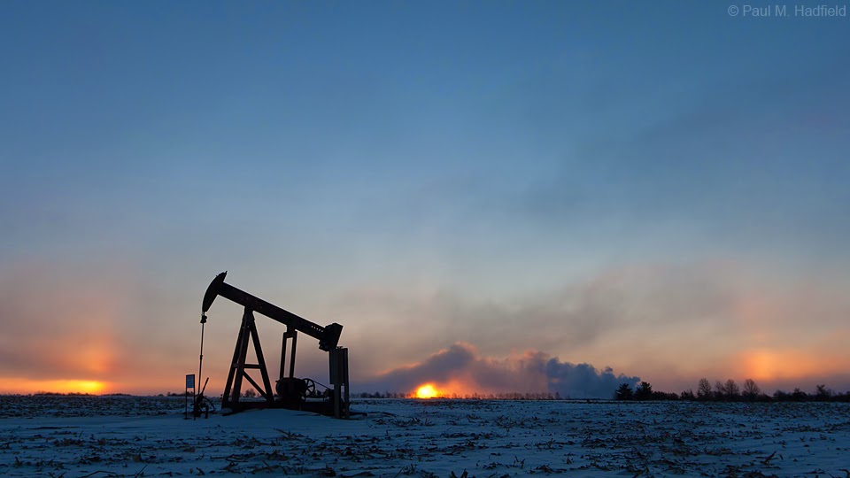
Glad I did.


Looking ENE, a miniscule amount of frozen precipitation was enough to help generate anticrepuscular rays underneath the cloud base streaming away from the above scene.


Probably should have time lapsed.


Traveling south as I was simultaneously running an errand, the miniature complex lost definition but the end of day light was still captivating.


Distant activity to the southeast was much more interesting so I switched to the 300mm.


Pileus Cap


Though much time had passed, the distant orange core is formerly that which was at Taylorville in the above radar capture but by now somewhere near or past Sullivan.


Lucky for any photographers that may have been out in that area.


Saturday, January 11, 2014

Polar Vortex

By now you may have heard this over as well as misused expression in the media regarding the historic event to recently pass. Brutal as it was, the arctic circle did not deviate from the pole but rather, a large dip in the jet stream pulled a chunk of exceptionally cold air down across the lower 48. Although many temperature records were broken, this phenomena is not uncommon during winter in the northern hemisphere. Locally for Decatur, we received about 7" of snow but what made this unique was the high wind that contributed to negative double digit wind chills. I was holed up at a hotel for the worst of conditions and stepped out periodically. These were by far the coldest temperatures I have personally experienced but to do so was totally worth it.

Sunday evening looking SW at I-72/US 51 as the snow was departing.


Looking for lines with a wind chill of -23°.


You know it's bad when the plows have to get behind this guy.


Monday morning I walked 1/4 mile up the road so to get sunrise from an open vantage. Unsure of what to expect, it was only fitting that an unbelievable atmospheric optics event would accompany the air temperature of -10° and wind chill of -36° that was reported out at the airport during this time. Per the first image, I thought it was a sun pillar before realizing that it was an intense sundog off to the side for the sun was still below the horizon and masked by haze.


Heading back, an officer rolled up and asked if I needed help. It was my friend Mark who was surprised to see me. Despite normally being a busy thoroughfare, his was the only car to pass in the time I was out as all state and county roads were closed indefinite. Pairing him with the 'superdog', I would catch a generous ride back in style.


As the morning progressed, the halo/sundog combination persisted but by now a circumzenithal arc appeared nearly overhead.


Tuesday morning was still ridiculously cold with lows in the negative range but with sunrise came the peak of the event as temperatures were forecast to slowly climb. I could and probably should write more regarding everything from the past several days but am somewhat exhausted from it all and will opt to just keep it simple. So just how cold did it get? More information can be found HERE.


Tuesday evening.