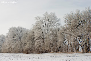
Some shots from around the area this morning.
Tuesday, January 25, 2011
Saturday, January 22, 2011
Anger Management
Friday, January 14, 2011
Epic Hoar Frost Event
"Epic" and "Event" are two words that no self respecting blogger should ever use, yet in a Facebook post from Thursday relating to this event (oops did it again), I made that horrible mistake. I blame fatigue but no less, the deed was done and I will try to not do it again. As for the "epicness" of the mentioned hoar frost in the title, it was fairly impressive. A moderate snow pack coupled with single digit morning low temperatures produced thick frost resulting in a beautiful scene across the region. I got off to a late start and didn't quite get what I wanted as far as ideal time of day light but still managed a few interesting snaps. At peak I was along the backside of a tree line when a gust of wind kicked up and blew the frost off of the limbs. I managed to set a camera up in time and get video of it coming down which looked like snow even though it was not snowing. You can see it HERE.
Monday, January 10, 2011
Hawks n' Hoar Frost
Between errands early Sunday morning, I dipped out into the country to enjoy the single digit temperatures and look for frost. At a frozen ditch somewhere off of IL 48 I came upon a miniature crystal forest.
Heading out.
Throughout the morning I saw numerous Red Tail Hawks and for once, was able to take advantage of the opportunity.
Next stop, Sand Creek Park.
Heading out.
Throughout the morning I saw numerous Red Tail Hawks and for once, was able to take advantage of the opportunity.
Next stop, Sand Creek Park.
Tuesday, January 04, 2011
Quadrantid Meteor Shower
In the darkest hours before dawn today, I decided to try my hand with documenting the annual Quadrantid Meteor Shower. The window of opportunity for this display is very limited so for being where I was and surrounded by considerable light pollution, I was very surprised to get what I did. I was also fortunate to witness the first (and best) meteor in this series. Today marks the passing of our mother so the experience although easy to rationalize was also somewhat comforting. Be sure to check out the video link at the end of this message for a time lapse series set to real time audio from the session.
as is facing NNE.
27 minute stack (54 images shot in succession, each exposure is 30 seconds).
as is.
another 27 minute stack, NNE again.
26 minute stack, no meteors, facing E.
31 minute stack, no meteors, facing SSE, large trail at bottom is Venus.
28 minute stack, facing NNW.
VIDEO LINK
as is facing NNE.
27 minute stack (54 images shot in succession, each exposure is 30 seconds).
as is.
another 27 minute stack, NNE again.
26 minute stack, no meteors, facing E.
31 minute stack, no meteors, facing SSE, large trail at bottom is Venus.
28 minute stack, facing NNW.
VIDEO LINK
Saturday, January 01, 2011
New Year's Eve Outbreak
For a year that will not soon be forgotten in having produced an incredible amount of severe weather nationwide, it seems only fitting that the last day of 2010 would go out as one of historic notoriety. Central and SW IL over into MO were among those areas favorable for the formation of strong storms which did not waste time getting under way. At home and much earlier than I had anticipated, I watched as a training line of HP (high precipitation) supercells lifted NW from extreme SW IL. I took interest in a cell located extreme SW Morgan county and headed up into Logan county for possible intercept. I chose to go NW as storm motions were relatively fast so had I taken a W or SW approach, I would have never caught it. By the time I got through Elkhart, it was at Petersburg and producing significant damage. I jogged N to just S of New Holland which is where my encounter begins.
The storm now well past Petersburg and still tornado warned was very low contrast. This is looking WSW at the flanking line.
The area of most significant interest (though not appearing to be doing much as I believe it was in the process of cycling) would intensify upon passage.
Again with storm motions being difficult to manage, I basically had to keep moving. As I did, the rain would clear from under the base to reveal the following which appears to be a wall cloud replacement cycle complete with roping out funnel (left) and new development (far right). I was never able to verify if there may have been a tornado on the ground. This image has been contrast enhanced to reveal detail.
Note the separate little scud funnel just below the power line.
This is the image I initially posted to Facebook only better processed and left not rotated for effect.
Meanwhile I kept my eye on the SW flank for a persistent funnel that did not appear threatening but bore watching.
With the storm quickly drifting away, I attempted a somewhat creative shot before letting it go completely. Not long after, the storm would lose it's warning and the IL chaos of this day would for the most part be done.
With so much destruction not only in IL but also MO and elsewhere, coupled with the loss of life, the jubilant expression of "Happy New Year!" is hard to come by. I simply pray that 2011 is our safest and most prosperous year yet.
NWS Lincoln will be conducting surveys eventually found HERE while additional storm reports c/o SPC can be found HERE.
The storm now well past Petersburg and still tornado warned was very low contrast. This is looking WSW at the flanking line.
The area of most significant interest (though not appearing to be doing much as I believe it was in the process of cycling) would intensify upon passage.
Again with storm motions being difficult to manage, I basically had to keep moving. As I did, the rain would clear from under the base to reveal the following which appears to be a wall cloud replacement cycle complete with roping out funnel (left) and new development (far right). I was never able to verify if there may have been a tornado on the ground. This image has been contrast enhanced to reveal detail.
Note the separate little scud funnel just below the power line.
This is the image I initially posted to Facebook only better processed and left not rotated for effect.
Meanwhile I kept my eye on the SW flank for a persistent funnel that did not appear threatening but bore watching.
With the storm quickly drifting away, I attempted a somewhat creative shot before letting it go completely. Not long after, the storm would lose it's warning and the IL chaos of this day would for the most part be done.
With so much destruction not only in IL but also MO and elsewhere, coupled with the loss of life, the jubilant expression of "Happy New Year!" is hard to come by. I simply pray that 2011 is our safest and most prosperous year yet.
NWS Lincoln will be conducting surveys eventually found HERE while additional storm reports c/o SPC can be found HERE.
Subscribe to:
Posts (Atom)