Tuesday, November 04, 2014

October Tornadoes / Mandi

The post below has been sitting in the queue for awhile and is of the least of my concern other than as a vehicle to deliver the most difficult announcement of my life being the sudden unexpected passage of my daughter's mother Mandi Morlan (obituary). On the morning of the 22nd she had a stroke that despite the timeliness of our action was too severe. I'm not comfortable in making this acknowledgement publicly but the past two weeks have been so unimaginably overwhelming that it just needs to be said. With respect to this blog and what I am known for doing, the future is questionable as my attention is wholeheartedly focused on our daughter while we deal with this grossly unfair tragedy. The amount of compassion extended to us in this extraordinary time has been humbling and we are exceptionally grateful. She was my right hand with an answer for everything, there really are no words to describe our loss.

Evening of the 28th.


~~~~~~~

Monday October 13th was a bit hectic across Central Illinois and more specifically my area. Though storms with the potential for producing severe weather were in the forecast, the thinking was that it might not happen due to limited instability and cloud cover despite adequate shear (turning of winds with height). Awaking that day and looking at radar, widespread showers led me to believe that it was just going to be a gloomy afternoon. A circulation center noted on radar lifting from near I-70 caught my attention so I got up, heated some coffee and casually hit the road. With it being a holiday I had time to spare and saw the opportunity to do some local leaf peeping while moving to position where it would pass as to potentially get a structured shower against fall color. Still well south at Assumption, it began to take on better definition as well as earn tornado warning. By now I was on the east side of Decatur near Long Creek and simply waited, knowing it would not be long till arrival given that it was moving at about 40 MPH. Ideally I would've liked to have been south where a stronger tornado occurred and might have had I been aware that there was a mesoscale discussion for our area. Instead, I didn't bother to look at anything including social media and went on straight visual based upon radar trend. Somewhat proud that I made my own 'forecast' for simply looking at rain though I should have been more attentive.

Waiting...


The storm as it approaches the southwest side of Mt. Zion and an unnoticed hitchhiker inside the hood!


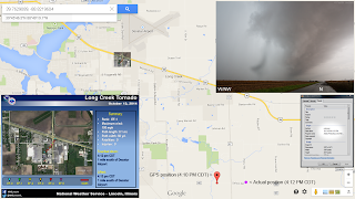
Quickly re-positioning as to be closer to the area of greatest concern, this shot was initially dismissed as an unknown lens anomaly. On comparison to the file exif data time stamp and my GPS location with respect to the official weather service SURVEY, this is in fact the EF1 tornado to spin up over the US 36/121 juncture. I was so enamored by the strong upper rotation that I never noticed what was happening at the surface but there too, I was in this spot for a minute and nine seconds per corresponding video time length reference. Unfortunately, the tornado is just out of frame on video because unlike my 10-24 wide angle, my dated little Handycam does not have the same range. I just set it up and walk away but there too, was not expecting to document anything other than structure. Of the three shots popped off in this moment, I wish I would've been vertical for the first as to know what it looked like beyond the upper edge and high into the updraft. This is surely a rare example of what a true spin up looks like in an HP (high precipitation) environment literally seconds before occlusion.


4:12 PM above, 4:13 below.


Continuing to northeast of Cerro Gordo.


Though impossible to see surface activity for crop interference, the storm is now over rural Argenta and producing again per the survey to file time stamp comparison. From here I let it go for being low on fuel with no nearby options available; another oversight for being inattentive and lax. Hindsight being what it is, don't let your guard down on a low instability setup if there is ample shear present.


Later that evening.

Saturday, October 11, 2014

Blood Moon II

The second lunar eclipse of 2014 came to pass on the morning of the 8th and fortunately under clear skies on a night off that I could be out away from city light. Initially I wanted to create a time lapse sequence of the entire event but failed due to camera malfunctioning issues. I still got the majority of it and even played around with a separate fun idea that my kid could share with her friends.


Reflection in a flooded tire rut.


Wednesday, October 01, 2014

Storm of the Summer II

Arriving home around sunset under a ridiculously heavy thunderstorm with intense lightning ongoing at the time, I decided to wait out the deluge vs. attempt to get fuel. The nearby CG's occurring in rapid succession were by far the most extreme I have experienced in recent memory if not ever that I am consciously aware. From far NW IL, sprites were observed from high above the distant complex which is a rare phenomena you might not necessarily expect here (wiki). One strike hit a substation down the road resulting in a fairly expansive power outage. With no electricity, the nearest gas station had to close but I didn't want to be far from my household anyways since they were in the dark. As the storm departed and the rain stopped, crawler activity on the backside emerged. Trudging up the block that was awash in heavy street flooding to position away from obstacles, I set up in an open soccer field. Without question, it was the most prolific display that I struggle to find comparison to with the closest exception being a night in August of 2008. Activity was confined to the upper anvil with multiple streaks passing directly overhead and filling my wide angle in its entirety.


Back home from the porch.


Venturing out on fumes to where I learned that power had not been interrupted in the hope of finding an open station as well as food for the household since we couldn't cook, luck would fortunately prevail. After dropping off dinner, I spent the remainder of the event out in the country where I would have preferred to be the entire time. No complaints though as this was by far the Storm of the Summer.


Sunday, September 28, 2014

Storm of the Summer I

August 26th was without a doubt the most incredible lightning event of the 2014 season. A lone cell to fire from just NW of the area would quickly mature into a ridiculous CG (cloud to ground) producing beast. Though I was unable to image any of the strikes while it was still daylight, the level of intensity was both extremely unsettling and on a level I have not experienced in recent memory. Two things I wish I had thought to do was a.) get video and b.) study meso-analysis to better understand why it was so insane with emphasis on regional CAPE values at the time. Beginning from NW of Decatur, lightning would not become an issue till NE of town out near Argenta so initially, I thought it would simply be a leisurely end of day structure tour.


This was where it began to get serious for while standing between a 200' power pole span, lightning struck the pole to my right placing me 100' from the point of contact. I would spend the remainder of the time inside a vehicle.


This scene does no justice for demonstrating the CG barrage occurring at the I-72 exit near Argenta. It was an incredibly beautiful storm but far too dangerous to be outside plus I was low on fuel and unable to stay ahead.


Abandoning so to backtrack for fuel, I was disappointed for not being able to get well ahead to somewhere safe as it was also capturing the light perfectly. Thinking this was it for the day with this particular storm now getting away from me, I was not prepared for what would come with nightfall.

Saturday, September 27, 2014

Gusty Storms

Back on the 25th of August, a line of storms well north of Decatur cashed out and ejected a massive surface outflow boundary. Though it was very defined on radar it wasn't very photogenic where I was but certainly packed a punch on arrival. Wind damage in the form of downed trees was reported in Mt. Zion. I took a short drive into NE Macon County to see it for myself. The intent was to practice time lapse but it ended up not being worth all the clicks.


Looking east, Pileus Cap on a cell hovering over Eastern Illinois


By now it was very windy, if not for the crops it would have been very dusty as well.


Back at home and shortly after dark, a new storm went up on the tail end of this boundary on the east side of town.


Literally going to the end of my block, it was a prolific lightning producer. I posted this next image to a local news page and they aired it on the 10 PM broadcast.