Sunday, June 30, 2013

Macon County Funnel Clouds

A slow moving upper system currently meandering over the Midwest kicked off several showers and storms on Saturday. The item of most significance is that with the initial development of storms and especially the stronger ones, numerous cold air funnel clouds formed. I lost count of just how many genuine funnel clouds I observed. Factor in the scud fingers bearing "funnelish" characteristics and it's safe to say there was much to see in the skies across the region.

An early afternoon storm appearing healthy on radar got me out the door but was post mature on arrival.


The updraft base on convection going up to the east around 6:00 PM wasn't obscured by low cloud and thus a large funnel could be easily seen despite being approximately 12 miles away over the Macon/Piatt county border near I-72.


I would attempt to get closer via the interstate only to get cored for lack of exit. Driving south through heavy rain, I finally broke free at Dalton City. Thinking this cell might be done, I was treated to a massive lowering that only looks small due to wide angle distortion. Although it dissipated, decent rotation could still be observed in the upper levels. This storm was much more than a pulse shower.


Heading back north towards home and satisfied with the afternoon, while on 51 I noticed a new cell to the NW near I-72 W of Decatur. I was stunned to see rotation on velocity so I detoured at the 72/36 split and headed towards Niantic. My expression was one of absolute disbelief with what I was seeing cross the interstate from right to left. Below is an edited phone pic.


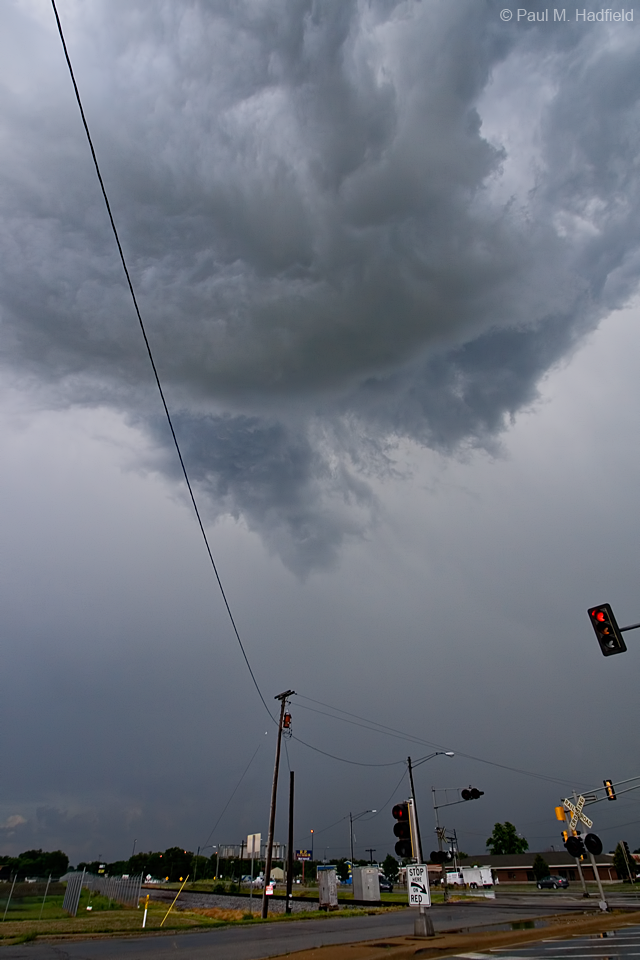
Pulling over just E of the Niantic exit, the wide angle might not have been the best choice for documentation but it was still incredible. The funnel was exhibiting very strong rotation and briefly drew fog/condensation up from the ground! I don't know if this constitutes as a touchdown and at no time did the exchange appear threatening but it was still an amazing sight. I believe a local surface outflow boundary ejected from the back of a cluster to pass through this location earlier may have been present and served as the mechanism for enhanced vorticity with this cell. Per the final image, the base became separated and lost much of its vigor as is typical once a storm has cleared a surface boundary. All in all a very interesting and unexpected event which seems to be the case around here lately.


Wednesday, June 26, 2013

Nature / Sub Severe Storm

After work but before businesses opened, I went for a walk. Did you know aquatic snails sleep on trees and other elevated surfaces? I didn't.


Wasn't really up for spending time with storms yesterday and slept through the overnight lightningfest but did manage to grab a shot while momentarily out prior to initial MCS squall line passage.

Tuesday, June 25, 2013

Severe Thunderstorm in SE Logan County Illinois

A massive MCS prompting numerous severe thunderstorm as well as tornado warnings in Northwest Illinois was the main focus for the afternoon. That said, when a much smaller complex trailing down into our area also earned warnings, by comparison it was somewhat of a surprise. I was already out and conveniently found myself within the warned area upon issuance. Unlike last post, it wasn't the most photogenic storm but the lightning for which I failed to capture was particularly intense. Personally, I'm ready for a break from storms even though that does not appear to be happening in the near term.


Public radar feed is generally delayed by about 5-7 minutes but yesterday, updates were at times over 20 minutes late. Why this was I don't know but even with the delay, it was still far better than the old days of no radar, no polygons and only a radio broadcast to go by if there even was a warning issued for a storm.


c/o RadarScope

Per the above time stamp of 5:40, the line was actually on top of me.


Sunday, June 23, 2013

Kaskaskia / Storms

Spent some time at the Kaskaskia River State Fish and Wildlife Management Area located SE of Sullivan IL last week. Much of the river flood plain was still inundated and thereby inaccessible. You'd never know that we were in severe drought at this time last year. Was more inclined to walk instead of take pics although a hidden fishing hole was a fitting representation for the last day of spring.


A decaying MCS and associated gust front dropped into the area Friday afternoon. There wasn't much to see with the line of storms but gusty winds out ahead kicked up a gustnado in the vicinity of I-72 and US 51 as well as brief landspout type of funnel cloud that I was able to catch the end of.


On Saturday, a large complex of mature storms training over the Champaign area belched out a strong outflow boundary that shot westward along the I-72 corridor. Often, as these cold pools of air from previous storms race across the land and encounter warm, moist, unstable air, they help generate new thunderstorm development which is exactly what happened over here in Macon County. A sub-severe cell bearing quasi-supercell characteristics shot up from outside of Warrensburg and exhibited impressive NW facing base structure as well as frequent lightning before collapsing into a massive rain core that prompted flash flood warnings in SE Logan County. I awoke in time to notice this activity so with coffee in hand from up the street, this is how my day began.


Friday, June 21, 2013

Tuesday's Slight Risk

First up, Monday's sunset.


The very first cell to go up and earn warning for hail and wind did so over Decatur. I was running errands and conveniently found myself under the updraft region which exhibited noticeable rotation. At the intersection of 121 and 36, I was even treated to a "faux"nel almost directly overhead. Wide angle distortion creates the illusion of distance but for sitting at a long light that I typically dread, it was cool to have time to watch the motion through the sunroof.


The cell would eventually weaken and lose the warning yet remain photogenic while it drifted SE as new development back built towards the NW.


Long Grove Cemetery


Another cell would develop in SW Macon County.


and then another with even one more after this that would earn a warning making it two severe thunderstorms for the county in one afternoon.

Wednesday, June 12, 2013

Gamma Delphinid Meteor / Nature / Severe Weather

A rare and brief meteor shower known as the Gamma Delphinds occurred early Tuesday morning for which I was fortunate to capture one of two that were personally witnessed.


Later, I went for a walk and was treated to the welcome return of a few odonates that I had not seen since last year if at all due to the severe drought.


Pools of standing water dotting a flood plain of the Sangamon River were teeming with inch long salamander larva. A camera card case provided ample room as a mobile aquatic studio.


Finally, the potential exists for a widespread severe weather event later today and tonight for much of the Midwest. All modes of significant activity can be expected with the greatest threat being that of damaging straight line winds. Persons in or near the shaded areas should be on guard and have a plan ready in case of power outage or other adverse outcome. Tune in to local media or follow your REGIONAL WEATHER SERVICE OFFICE (click to your area) for detailed information as it evolves.