Wednesday, August 29, 2012

Pre-Isaac

Tuesday morning while Tropical Storm Isaac was still churning in the Gulf of Mexico, I began thinking about possible implications around here and decided to go for a walk down by the Sangamon river basin. Forecast talk even that far out hinted at the potential for this storm to carve through the Midwest and inundate those areas exposed by the drought to where they become inaccessible. The arid conditions have created opportunity in a sense for opening places to explore along with concentrating local fauna around available water sources. The time for waterways to resume their natural function instead of as pathways is however, sorely overdue. If Hydrometeorological Prediction Center estimates for the Central Illinois region verify, this change will hopefully kick start needed recovery from this historic dry spell.


Snapper with an Asian carp.


Unrelated experiment from later that evening.

Monday, August 27, 2012

Great Egrets

The other day I noticed a large flock of Great Egrets at a southern inlet on Lake Decatur. Saturday evening I went to see if they were still there and was in luck. The extreme distance coupled with shadowed light made for less than ideal shooting conditions but I tried anyways. Working to my advantage both for why they along with several other bird species were in abundance was the significantly low water level. Normal summer measurement is 614.0 feet above sea level whereas at the time of this writing is currently at 610.79. Tropical Storm ISAAC still churning out in Gulf of Mexico may swing up through the Mississippi valley late next week and bring sorely needed beneficial rainfall. Too little too late to save crops but a drought buster or two before winter sets in would be a blessing, we can only pray.


The egrets would eventually leave but I stuck around as there was other activity including a large flock of geese that came in not to mention a Great Blue Heron. Tough shot for being right at twilight and requiring slower exposure as well as difficulty focusing but figured it was still worth showing.

Sunday, August 26, 2012

Sunday Structure

Non-severe storm with persistent base features from NW of Warrensburg today.


Beneficial heavy rain maker from the SW later.

Saturday, August 18, 2012

Photobomber

While spending a moment with a damselfly to catch my attention yesterday evening, a leaf hopper decided it wanted in the picture. Just as I was going for another shot, it rounded the edge and spooked the damselfly which instinctively took flight. The action occurring within 1/5 of a second resulted in a ghosted double image of the damselfly whose tail you can see in motion as it jumped backwards.


Friday, August 17, 2012

Ava vs. Outflow

Despite the ability to spend time with Thursday's weather, I opted to sit out on the latest event. Six day work weeks for nearly two months have me somewhat burnt out and I'm ok to pass on a limited color or contrast midday linear event. That being said, I noticed a well defined outflow boundary (a.k.a. OFB) on radar ejecting from ongoing morning storms to the north and heading our way. Identifiable as a thin green line moving away from the general direction of storm movement, this is the signature of an arcus cloud which is typically accompanied by brief, gusty winds but otherwise generally harmless. Heading up the street for a better look, Ava rode along and though unconcerned as usual for the most part, she ran around trying to catch blowing leaves once the winds picked up so as to "save them".


Don't know what her fixation was but for a candid I'll take it.


Facing W, these are all edited phone pics.


Radar grab c/o Radarscope showing the OFB just after it had passed our location at Decatur.


Falling asleep for a bit after having been up all night only to later be awakened by thunder, a customary peek at radar showed another OFB heading our way. With respect to the first picture which garnered considerable support elsewhere, I decided to have a little fun with Ava who was all for the idea :)


The arcus cloud would wash out for coming into more stable air that was turned over by the previous OFB but we still had fun. New storms would soon develop to the W and dump moderate rainfall at home where I simply enjoyed from the porch. Cells in Christian county to the south would later intensify and begin to show signs of damaging straight line wind potential per velocity. Moving into Shelby county they would ramp up significantly to earn an eventual tornado warning. It is worth noting that what Ava and I experienced had nothing to do with the dangerous activity occurring and was merely a non-threatening byproduct of a distant dying thunderstorm complex.


Screen captures fascinate me and especially when people are involved. The lead dot near the strongest return is the Spotter Network icon of Brad Emel who documented the worst of the storm as seen in his incredible VIDEO.

Thursday, August 16, 2012

Harristown Illinois Funnels

Tuesday afternoon was a day like any other with not a whole lot going on when Facebook started blowing up with people near Clinton talking about funnel clouds. This naturally caught my attention so between errands, we looped out into the country and under a broad shower complex where sure enough, directional shear resulting in funnel cloud development was occurring. Ava was along for this adventure and though she could have cared less as it was also both non-severe and non-threatening, the opportunity was a fun surprise.


Big circulation would wrap up into a semi-transparent needle that I was unable to image well due to lack of contrast. It would then occlude only to wrap up into a blunt funnel to pass nearly overhead. Most of the funnels observed were very small and brief with the exception of this feature. Time lapse video of this area can be seen at the end.


DSLR pic and it's in there, very hard to see as it blends in but is just right of the lowering and almost directly above the center transmission tower. It hangs about halfway down to the cloud edge. How my ISO got bumped up to 800 I do not know but it did not help the situation for also being pointed at a direct light source.


Blunt funnel at top left vs. Ava lower right.


Heading a little further west and facing back to the east, the now dissipating structure was still producing funnels as well as a faint rainbow. Apologies for the image quality as most of these are edited phone pics. I was having issues with the regular camera made worse by discovering later at home my ISO was accidentally set too high.


Monday, August 13, 2012

Champaign County Wind Storm

This past Thursday August 9th, a few storms dropped in from the NW as was expected to be the case and quickly went severe. The first warned cell caught everyone's attention but the one to its S would go on to be the story of the day.

Images c/o Radarscope


I'm the bottom dot on 
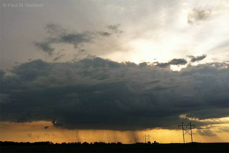
Spotter Network moving up from the SW along I-72 between Forsyth and Argenta. The first photo is from close to this time as I was by then, just past Cisco.


Exiting at Monticello so that I could stay S of Champaign and avoid traffic, once I got E of town, I pulled over close to where I photographed the May 1 tornado and watched the SW flank. It was at this time that the storm shed its outflow along with associated cloud and appeared to be reorganizing. The area was starting to bear somewhat LP structure so naturally I was hoping for some magic which presented itself in the formation of a skinny funnel within an area of loosely organized vorticity. The storm was predominately cold and outflowish so this activity was both anomalous and brief. Hindsight being what it is, I wish I would have shot video but the last thing I expected to see today was anything remotely tornadic although this was the least threatening aspect.


The storm would go on to produce a massive downburst rain foot from S of Champaign that I tried to spend time with but was difficult due to being on the move. It was much more pronounced towards the right and out of frame.


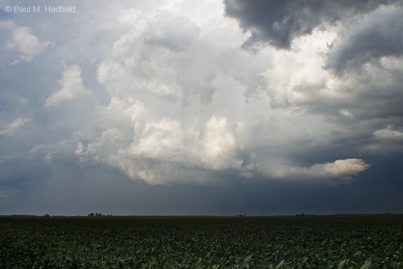
Continuing E, as I got further along and now S of Sidney is when it started to get real. Small debris littering the roadway in a uni-directional manner suggested that strong straight line winds came through with the observed downburst. Cresting the hill I was stunned to find a large tree down as well as numerous medium sized branches. It was here I also had to clear the roadway of limbs (not shown) which posed a significant traffic hazard.


After the previous shot I would call in what I observed thus far only to simultaneously encounter much more including a tree that completely blocked the road as well as flattened crops. Pausing to grab material upon completion of the call for a panorama featuring the departing culprit, I doubled back to document the area of the fallen tree.


Surveying the location, I was stunned to see more large trees back within a grotto on a private residence having been downed. It did not appear anyone was home at first nor that structural damage occurred so I stayed back. A vehicle pulled up from opposite the side of blocked roadway at which point I asked the driver if this was his house to which he said "no". I then preceded to mention that a chaser by the name of Andy Wycislo said that Broadlands had damage as well to which he said "I'm Andy". This was a pleasant surprise as we had been friends on Facebook though had not met so we both took time to check out the area and talk. In the meantime a kitten emerged from the tangle of branches to greet us. It was soaked and seeming a little shaken from the experience but very friendly.


My images do no justice for expressing just how extensive the damage was to the local corn and bean crops that were flattened as far as you could see; literally hundreds of acres if not more. I have seen straight line wind damage but nothing of this magnitude. Since I followed the storm from a safe distance and only experienced marginally severe gusts while driving, I was unaware that just a few miles ahead, all hell was breaking loose.


Andy and I eventually parted ways with me going N and he respectively S as there was no circumnavigating the tree. Every residence I passed had some sort of tree damage and for some, unfortunate structural damage including a smashed van with blown out windows at one location. I try to be respectful when it comes to significant loss so no shots of personally identifiable property but a plum tree stripped of its fruit as well as overturned cart effectively illustrate the intensity of this storm. Andy would go on to document perhaps the most sobering aftermath of this high wind event being a train derailment. Check out more of what he does via his website www.andywycislo.com.


Note the beans.