Monday, June 27, 2011

June 25 - 27 Storms

Much like the flooding event of last week to affect portions of SW IL, storms fired along a warm front stretching from WC into SE IL on Saturday evening. A series of discreet cells went up initially with one in particular to earn severe warning in Sangamon County near Springfield. I was out doing errands and dropped S for an intercept at Assumption though on arrival it had lost it's warning. Hoping for lightning to fire in frame with structure, I had no luck but was able to get enough material for a brief time lapse series found on THIS video link. Upon passage, storms exploded and continuous lightning akin to a strobe could be seen in all directions. Heavy rain with numerous flash flood warnings would be the story for the rest of the night.


Sunday night into Monday morning, a similar setup took place with two MCS's (mesoscale convective systems) canvassing the region. The first to drop through around midnight although small in scale was mighty in the sense that it generated intense cloud to ground lightning once the initial squall line went overhead. The second MCS to track along I-72 was responsible for producing wind damage in W IL and had equally intense lightning. My location took a direct hit on the rooftop and as the discharge traveled instantly through the internal wiring, a loud *SNAP* like a firecracker was emitted from a plug near to where I was sitting. I doubt that there was a personal danger since it was guiding along an electrical pathway but thankfully none of my equipment was plugged in at the time. I had a camera set up for both rounds of storms and have assembled images into a DSLR time lapse series seen HERE. I also shot video on my iPhone of the prolific lightning and then extracted audio into a 2:00 minute audio clip that you are welcome to rip below.

June 27, 2011 - Early Morning Lightning (soundcloud.com)

First Round


Second Round

Thursday, June 23, 2011

Southern Illinois Magic

Tuesday June 21st was the annual solstice so what better way for nature to kick off the first day of summer than with a spectacular display of color and light across the entire state. Before this would happen though, several rounds of significant weather developed from S to N that prompted severe thunderstorm as well as a few tornado warnings statewide. Till all was said and done, only two official tornado reports verified in extreme N IL although storms to the S including the one I was on were inconclusive. A bow segment lifting along I-70 had a few pockets of rotation on the leading edge as indicated on velocity (which I failed to keep a screen capture). I would intercept the furthest N area from E of Cowden IL in extreme S Shelby County that was somewhat weak and would gust out in comparison to another to the S in Effingham County that was better organized. Everything was pretty much forced and storms were outflow dominate but at least the structure looked good for a minute. A few locals would stop to see what I was doing at which point I advised them of the tornado warning. The cars you see heading towards the farm were a group of young people who turned around to find shelter elsewhere even though they probably didn't need to. Their caravan makes for a fun addition to the video clip of this scene (link towards bottom). Also note the lucky push button CG's! Driving E from this location ended up placing me near to the area of interest lifting from the SW where I experienced small airborne tree debris as well as a sizable gustnado from close range.


Once the line passed and I was caught up in heavy precipitation, rather than keep driving, I stopped at nearby Hidden Springs State Forest. I have not been here yet so in thinking that chasing was done for the day, I decided to look for nature. Of the highlights was a female juvenile box turtle who in spite of the pictures was not the least bit afraid of me. Note the little mite in the second picture. It's a very peaceful destination that is well worth exploring.


On the way out...


Down from the park and back a secluded dirt road was a somewhat well maintained cemetery with stones dating as far back as pre 1900. In some areas, stones were almost completely swallowed up by the earth or else completely illegible so one can only imagine how old they might actually be. I'm not real into nor very good at artistic work like several of my photographer colleagues but I did score a few more periodical cicadas from the waning Great Southern Brood.


From the cemetery I would decide to go S again as another complex was moving up from St. Louis along I-70. Light of day was taking on a spectacular appearance and although I was never able to intercept storms in this golden light, updrafts and bases of a showery CU field in Fayette County were still worth documenting.


By dusk when the storms arrived, I was unable to get to the S side of the line but did spend time with lightning on the backside. Per the second shot, you should've seen the ones that got away!


Heading home and now after midnight, I paused in Christian County for a moonlight scene. Showers pulsing on a lingering outflow boundary to my NW coupled with Springfield city light made for yet another opportunity. The first star trail image is a stack comprised of 68 images equaling 22:40 with the second being 60 images making an even 20 minutes. Hindsight being what it is after assembling both stacks as DSLR time lapse clips, I wish I would have stayed out even longer. You can see this time lapse video as well as clip from the earlier storm HERE.


As if the above weren't enough, additional cells went up on the same outflow boundary only to collapse into a massive moonlit arcus cloud in Macon County. It was nearly overhead by the time I found a location to pull over but served as a fitting end to what was a highly productive start to the summer season.

Monday, June 20, 2011

Recent Weather (and other stuff)

It's been a very busy time as we have been stuck in an active pattern that has produced multiple rounds of significant weather across the region. I've been fortunate to document something from just about every event while still keeping up with the demands of day to day life.

June 10 - On this day a fairly well organized storm would drop into the state and despite maintaining a long lived tornado warning, it would become a big wet mess upon arrival to our area. I headed out with CAMERON CROSBY whereby instead of go for the old storm as seen in the radar capture, we would spend time with an independent miniature supercell to develop out ahead of the line. Once this low contrast cell as seen in the first still was done, we had a choice, drive N into the nearly exhausted tornado warned cell or drop S to go for new development. Opting for the new development, we were treated to an unwarned line segment to produce amazing structure and some incredible lightning. Time lapse video of both storms can be seen HERE.


June 11 - The cicadas have peaked and with that, have been dwindling away. The males are the first to die off with the females later following suit once they have deposited their eggs. Everyone has an opinion of these creatures and though many are glad to see them go, I have enjoyed the experience. When they emerge again, my daughter will be 18 and I will have hopefully made it to age 50.


June 13 - Non severe formerly warned storm between Owaneco and Pana IL. The bridge graffiti had me laughing for being the most ridiculous statement I have ever seen. Mopar thanks you :P


June 14 - Overnight lightning associated with yet another MCS to pass under the cover of darkness. I sent this image into GREG TRUMBOLD of WAND TV who was very kind to show it at the end of his morning broadcast.


June 15 - A developing storm from S of Springfield bearing supercell characteristics caught my attention so I took off to check it out. Unwarned until after I intercepted, on arrival it was becoming very well organized with a solid inflow and wall cloud. The storm would quickly become more outflow dominate and drop SE as an HP (high precipitation) supercell but not before spitting some very intense CG lightning. I would remain in the vehicle for this storm while in the notch and shoot with my window mount tripod. Time lapse video of this storm can be seen HERE and as you view it, take note of the "click" sound when you see the artificial flash (I timed this audio segment to go with the video as intro). It is the sound of a spark emitting from a nearby power pole associated with the dangerously close lightning strike.


Heading back, this unimpressive cell bearing supercell characteristics as well would intensify and go on to produce a tornado about 15 miles SE that destroyed a barn in rural Shelby county.


June 18 - The storm in the following screen capture went up on a stalled OFB (outflow boundary) left over from previous convection and would become a huge story. In the area of W Sangamon and E Morgan counties, this cell would dump heavy rain for several hours. Official measurements of over 4 inches were observed with unofficial totals of 5 to 6 inches were reported. Considerable flash flooding took place over the area with warnings to last for several days due to swollen dam releases as well as a local levee breach in Scott county. The line would eventually fill in downstream resulting in blanket flood warnings from just S of where I was on the N end of Decatur. Since I was on the backside of this complex I set a camera outside and shot continuous for the intense lightning show that was occurring throughout. A few of the better stills are below but the real purpose was to assemble a DSLR time lapse video that can be seen HERE. As you watch the video, the two clips are comprised of 120 15 second exposures that encompass a period of 30 minutes each.


Taking the one batch of 120 frames, I ran them through the star trails program resulting in this unusual lightning stack. MIKE HOLLINGSHEAD is who turned me on to this technique.


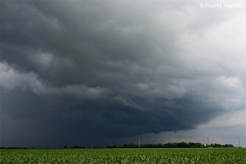
Early the next morning as the overnight system pushed on, a new one began lifting from the SW. Prompting numerous warnings across S IL including tornado on the leading edge, when the NE portion came into the area it was preceded by an impressive shelf cloud. Try as I did to get into a good location with minimal foreground obstruction, I was unable to get the shots I wanted including that for a panorama. My good friend and fellow chaser Jodi Irvin-Dewispelaere was able however to make an amazing intercept. Her images can be seen HERE. Note the widespread flood warnings in the radar capture.


Talk about impressive, note the "eye" of the mesolow center!