A very potent weather system the likes of which you might find in April passed through the region this day. A strong jet coupled with incredibly high CAPE values across N IL resulted in a significant damaging wind event across a vast area. Though the tornado threat was considered low, warnings were issued in the Chicago metro with a few confirmed touchdowns. As was expected, storms up N congealed into a powerful squall line that in spite of numerous warnings, lost intensity as it progressed towards the SE. Unlike many who ventured N to experience the worst of this event, I stayed close to home and only stepped out when the line was two counties away. On arrival at my location near Chestnut, a shelf cloud stretching the horizon was immediately followed by gusty outflow winds on the order of 35 MPH tops. Between the darkness of twilight, turbulent cloud bases and the wind rustling the corn, the scene appeared particularly ominous though wasn't. With the collapse of the squall line I was somewhat disappointed but not surprised. An isolated severe cell developing to the W towards Niantic/Illiopolis however, would redeem the outing by offering up a few lightning keepers.
Once this episode concluded, I headed back towards Decatur. Much later around 11 PM and well after the warnings were canceled, an isolated cell developed to the SW of Decatur and drifted over the city. My position enabled for clear S view from which I was treated to the best opportunity of this event.
With the exception of two rounds of severe thunderstorms to pass through the area, it was a quiet night at work so I was able to stick my head out the door on occasion. The first round though collapsing at the county line had a healthy gust front that kicked up winds around 35 MPH or so. This cooler air offered welcomed relief from the heat. There were also some rather intense CG lightning strikes out ahead of the precipitation.
The second line to come through was more towards the SW. Originating in extreme WC IL, significant wind damage was reported in Schuyler as well as Cass counties with many reports of downed trees and power lines. Upon arrival there wasn't much to see other than an exhausted shelf. On the backside of the complex and towards daybreak is when the real show would emerge with this event.
Note the crawler, I missed the better ones but no complaints :)
Around 3AM CDT we had a series of thunderstorms fire to the SW that immediately began putting down an incredible barrage of lightning. One cell in particular as seen in the first few images would earn severe thunderstorm warning and drift across the S portion of Decatur. Other cells would fire thus continuing the light show through daybreak. It was quiet so I was able to step out for a few minutes.
With several new cells having developed and training in the same general vicinity, sunrise light filtering through the cloud was almost surreal.
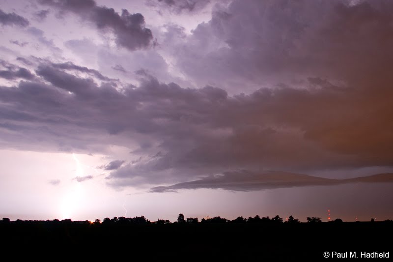
Much later as the main complex was pressing into IN, a mammatus display from N Macon county makes for a fitting end.
Better late than never, on this day I intercepted a severe warned storm from S of Warrensburg or basically just up the street. For several reasons including headache and lack of interest, I hadn't planned on going out but changed my mind at the last minute. The shelf cloud was very impressive though not nearly as intense as in some images I saw from others who captured it several minutes earlier.
Afterwards, I went home to wait out the rain. Towards sunset I went out again to see if there would be any color on the backside. Mammatus was equally impressive but would drift well E before the best light kicked in. I did try for daytime lightning though not very successful.
Note the faint rainbow lower left.
The faint rainbow from earlier gained intensity as the sun edged closer to the horizon. Without an ideal foreground present, I tried to make due with the 300mm.
Town of Maroa.
The nuisance cloud was disappointing but again, I tried to make the best of it.
Storms in Minnesota that produced violent tornadoes on Thursday congealed into a damaging squall line that dove SE across IA during the overnight. This squall line eventually lost its intensity however, the wind energy continued moving and eventually canvassed Central IL at around 6AM on Friday. Though harmless by itself as it is simply two colliding air masses of differing temperature and moisture content near the surface, it did enhance an ongoing local storm to the NE resulting in a brief tornado warning for Piatt and Champaign counties.
Meeting with a friend yesterday at this downtown Decatur landmark, I did not realize how rich in historic value this property truly is. The connection between Governor Oglesby, Abraham Lincoln and this house is quite unique. My visit was brief and I only saw the downstairs but we did throw around ideas for a future shooting opportunity. The mansion is open on Wednesday's from 1-4 PM. Admission is $2 upon which you receive a very thorough educational tour. More about this property can be found HERE.